
Water levels in a Salford village have exceeded existing records following torrential rain which causing overnight flooding.
Two warnings were issued for Worsley Brook by the Environment Agency last night (September 30) as water levels reached 2.08m, with the highest level previously recorded as 1.96m in 2019.
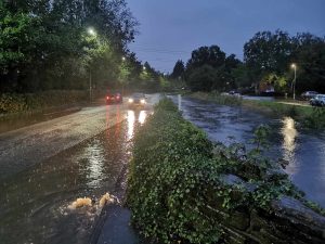
In yesterday’s afternoon report, the water level at Worsley Brook saw an increase from 0.16m at 11am, to 1.69m as of 5pm amid torrential rain.
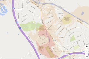
According to figures, readings of over 1.94m could lead to possible property flooding with areas most at risk including Alder Street, Hartington Street parts of Botany Road, Hastings Road, Grange Road, Worsley Road and the nearby allotments and playing fields.
There are currently three flood alerts and seven flood warnings across the North West.
Residents have been commenting about the flooding across social media.
One said: “The water is at top of the wall at bottom of garden, its starting to go down Walker Road, fingers crossed it doesn’t cause much damage.”
In a statement on the Government website yesterday, the Environment Agency said: “Areas most at risk include properties adjacent to Worsley Brook.
“We are closely monitoring the situation and monitoring rainfall and river levels. Start acting on your flood plan if you have one.
“Take care and avoid walking, cycling or driving through flood water.”
As of 10am, water levels have been restored to their usual state.


